
The steamer left Brisbane for Ipswich on a Monday morning in September. The “Ipswich” was a side-wheeler with a rudder at each end, and a shallow draft for navigating difficult areas such as Seventeen Mile Rocks and the shoals of the Bremer River.

Paddlewheels splashing rhythmically and smoke pouring from the tall funnel, the steamer made its way upstream, following the slow bends of the Brisbane River, past thickly-wooded, vine-draped banks that would one day become the suburbs of St Lucia, Chelmer and Fig Tree Pocket.
James Matthews probably stood on deck with a mug of coffee, watching the passing scenery and talking to his new boss, Benjamin Glennie.
It was 1861, and the newly-independent state of Queensland was actively seeking English migrants. James, my great-great-grandfather, was one of them. Aged twenty-three and ordained only yesterday, he had come to Queensland to work in Warwick as a curate.
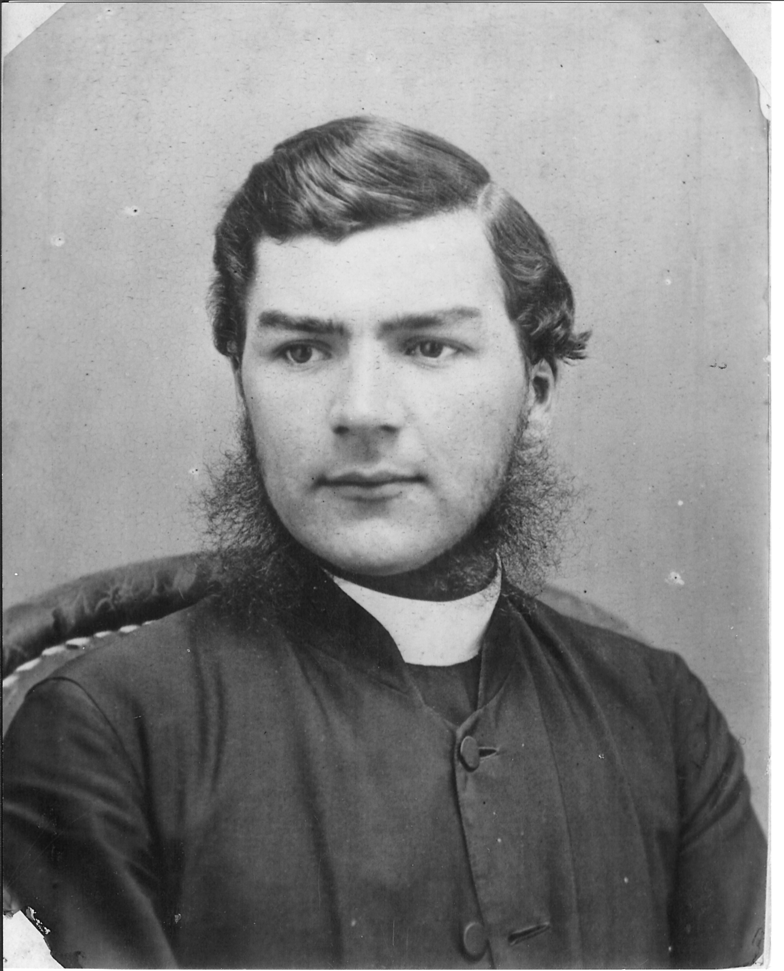 James Matthews
For years Archdeacon Benjamin Glennie, now the rector of Warwick, had been the only Church of England clergyman on the Darling Downs. The eccentric Glennie loathed riding, so his travels around his huge parish were mostly done on foot, and this is how he and James would be travelling from Ipswich to Warwick. On foot.
Forty years later, in memory of Archdeacon Glennie, James described the trip in detail.[1]
On Monday morning, we started on our journey to Warwick, travelling to Ipswich in the steamer of the same name. The voyage occupied five hours.
The next morning the real work of our journey began. The Archdeacon’s old black horse was brought round and packed with a couple of valises and a pair of large saddle bags, consisting largely of my belongings, and off we trudged, the Archdeacon leading his horse.
That day they walked south for twenty kilometres, down the present-day Ipswich-Boonah Road. The two men would have encountered bullock teams dragging wool from the sheep stations, travellers on horseback and on foot, and the occasional buggy. Many would have recognised Benjamin Glennie. Perhaps they offered them a ride.
They spent that night with squatter William Watkins at Peak Mountain Station, near present-day Peak Crossing, its homestead set on a rise with a spectacular view towards Flinders Peak.

The following day we walked as far as Balbi’s, an accommodation house at the foot of the Range.
All that Wednesday, covering over thirty kilometres over flat land and gentle hills, they would have seen ahead of them, through the trees, glimpses of blue mountain ranges.
In 1861 there were Aboriginal people living in this area – probably Ugarapul people. The two men must have met them on the road, but James left no mention of it.
Ironically, most of the roads walked by Benjamin Glennie and James Matthews would have been based on ancient trails of the Indigenous people who had been walking this country side for many thousands of years.

The two travellers spent that night in Balbi’s Inn, at the bottom of the range, beside the road to Spicer’s Gap. I’ve driven up that rough, gravel road myself, to sit at Governor’s Chair Lookout and enjoy its fine views east towards Brisbane and the coast.
On Thursday we crossed the Range, going through Cunningham’s Gap. There had been a heavy thunderstorm, the mountain streams were swollen, and we had to “double-bank” to get over. The Archdeacon got into the saddle and I jumped up behind.
Wheeled traffic went over Spicer’s Gap, but riders and foot-travellers often took the bridle trail through Cunningham’s Gap. It would have been a tough journey up hill, but Benjamin Glennie was fit – according to James’s account he would vault a fence rather than stoop to go under it – and James was young. Looming cliffs and tall trees, the sound of bellbirds and whipbirds, cool air smelling of the rainforest: today they are still exhilarating, even though the way up the range is now a harsh slash through the forest, made noisy by semitrailers.

From the top of the Range, they followed Gap Creek west to William Jubb’s Inn, a low building overlooking the stream. These days, a farmhouse occupies the old inn site beside the Cunningham Highway.
On crossing the last creek, I fell off into the water. Fortunately I had not far to walk to the inn, where Jubb rigged me out in a suit of his clothes while mine were being dried. He was a much bigger man than me. There was no one near with a camera, I am thankful to say.

On Friday we lunched with Arnold Wienholt at his station Maryvale, in the afternoon proceeding onward to Glengallan, where we were put up for the night by that prince of squatters, John Deuchar.
All the land between Ipswich and Warwick was held by just six or seven squatters, members of the colony’s aristocracy. The Deuchars of Glengallan Station were famous for lavish hospitality in the sprawling cedar house where the two travellers spent that night. A few years later a new homestead was built, the elegant, now restored mansion visible from the highway.
After breakfast on Saturday morning we wended our way to Warwick, where we arrived in time for midday dinner, taking care to walk through the principal streets of the town so as to announce that the parsons had arrived and there would be church tomorrow.
Perhaps one day that walk to Warwick by Benjamin Glennie and James Matthews will be recreated. They were walking for a spiritual purpose, so it would be a kind of Queensland “Camino”, like the pilgrims’ pathways through Europe and Spain that are now so hugely popular. Great walks exist in Queensland, too, along ancient Indigenous pathways. We should pay more attention to them. Although they don’t pass through quaint medieval towns, they are just as old. The bridle trail through the forests of Cunningham’s Gap was probably one of them.
James Matthews married a Warwick girl named Mary Margetts. According to a family story he met her on the Spicers Gap road, a year or so after his long walk, when Mary’s hat blew away, and James caught it.
People journey, and people love. Some things will never change.

[1]Excerpts from “A Few Personal Reminiscences of the Late Archdeacon Glennie” printed in “The Church Chronicle”, June 1, 1900.

Great story Rose. The link to indigenous pathways is obvious now that you point is out and the Camino is an interesting concept.
LikeLiked by 1 person
How wonderful to hear all these familiar place names and see them through James’ eyes. You are lucky to know so much of his story.
LikeLiked by 1 person
Yes, we are lucky. I had friends walk from Brisbane Toowoomba recently, taking a week to do it, and it made me think that I should do the Warwick walk. Maybe one day…
LikeLiked by 1 person
Phew, I wouldn’t fancy walking up the range. At least we’ve been having nice weather for walking. Could do with some rain soon though.
LikeLiked by 1 person