Islands

You don’t need special tools to husk and crack a coconut. You can do it with a rock.

I went with my family many years ago on a boat trip to Green Island, off Cairns, but for some reason we had no money. Not for us a café lunch with the other tourists. Instead we set off to walk around the small coral island, just one and a half kilometres, with only a packet of Arnotts wheatmeal biscuits to share.

Green Island postcard from the 1960s, about the time Dad cracked open the coconut queenslandplaces.com.au

There was food lying around, though – coconuts fallen from the palms that ringed the island. My dad, always the boy scout, set about opening one of them with a rock – slicing through the husk, then cracking the shell. Fresh coconut meat for lunch.

Back at the wharf with the other, well-fed tourists we felt the slight smugness of those who choose the more adventurous path.

Years later, I went again to Green Island with my own children. It was 1982, and Hayles Cruises had just begun a fast catamaran service to the island. A cold meat and salad buffet was served on the way.

Joe was not quite six at the time, and all he remembers of the day is not the glass-bottomed boat or the underwater observatory, but that to eat our lunch we were provided with double-bowled plastic cats’ dishes. Catamaran. Get it?

Green Island with a modern tourist catamaran greenislandresort.com.au

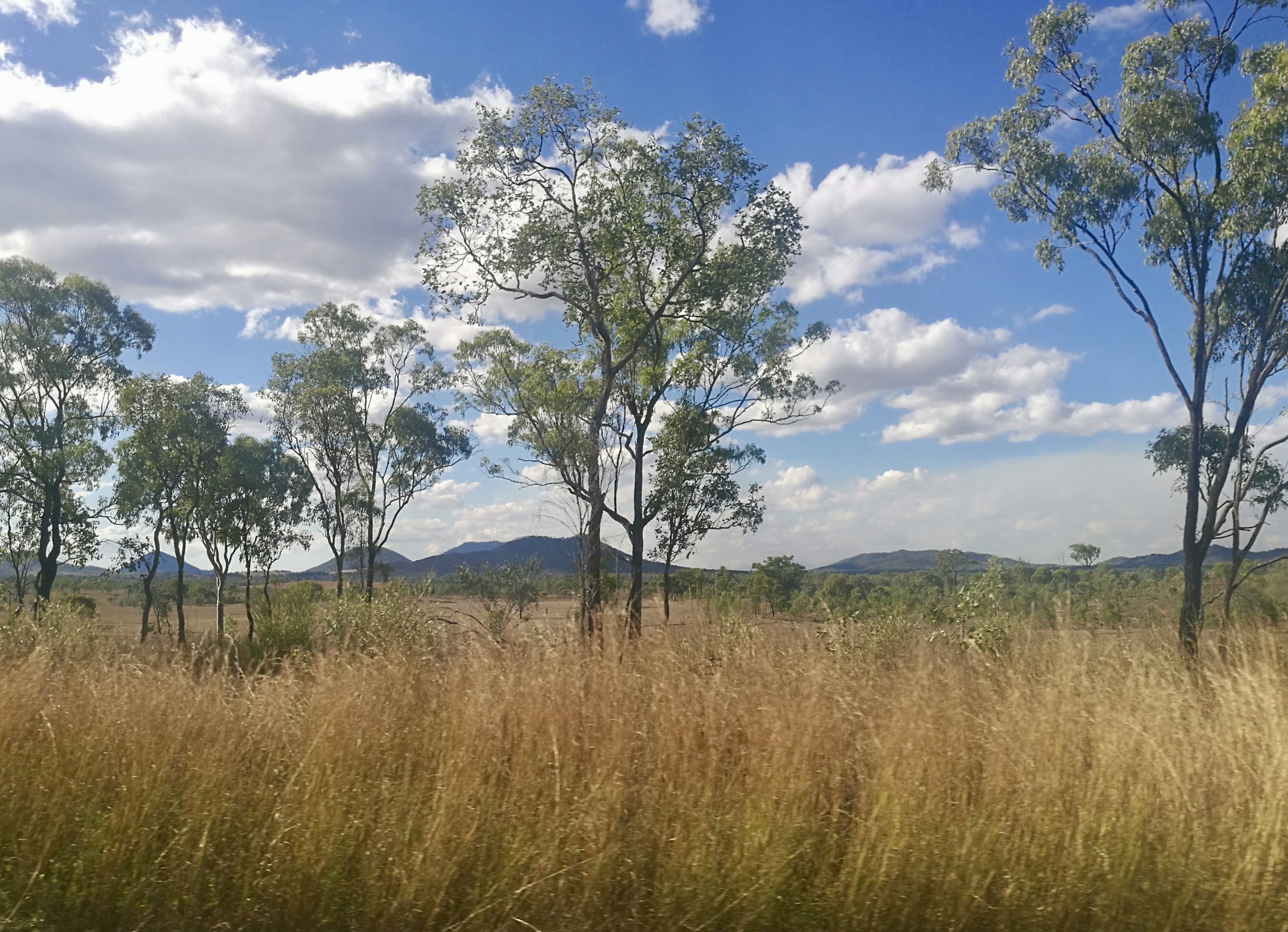
Queensland has a long coastline and many islands, spread over more than two thousand kilometres, from Torres Strait to Moreton Bay – rocky islands that are an extension of the mainland, coral islands and sand islands. Coconuts grow as far south as the Great Barrier Reef stretches, to the Bundaberg area. Some were planted on the islands by European expeditioners so there would be food for seafarers marooned there in the future.

Queensland’s islands attract tourists and people looking for an idyllic way of life, artists and academics of various disciplines and the occasional filmmaker and politician. The ageing James Mason and teenaged Helen Mirren starred in the 1969 movie “Age of Consent”, filmed on Dunk Island, off Mission Beach, surely one of the most idyllic islands of them all. It was great for the locals to see one of their own beautiful places on the big screen. Con and I watched it at the Airdome Theatre in Innisfail.

“Age of Consent” promotion, 1969 amazon.com

We watched it again last year, and found that our values have changed. The story of a naïve young girl persuaded to take off her clothes to model for the much older artist, and then having an affair with him, seems most unsavoury now.

I first saw Dunk Island (Coonanglebah in the local Indigenous language) from a holiday flat at Mission Beach, a much cheaper option than staying at the island resort. Islands are expensive.

Torres Strait, Australia’s most northerly region, has around 274 islands and coral cays, many uninhabited, with dry and rocky Thursday Island (Waiben to the locals) the administrative centre. There is a story about a group of marine scientists from the United States who went to the Strait to study dugongs. For weeks they went out in boats, searching the seagrass beds for dugongs, and found none. When it was time to leave, they were invited to a local feast. The main course was dugong.

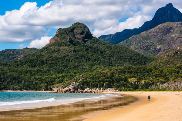
When driving over the Cardwell Range, we often stop at the lookout for one of Queensland’s most spectacular sights: Hinchinbrook Island (Pouandai) – a place of beauty and mystery.

Pouandai (Hinchinbrook Island) seen from the Cardwell Range lookout

Fifty-two uninhabited kilometres of cloud-capped granite mountains, jungle and waterfalls, mangroves and crocodiles and long, long beaches.

Hinchinbrook Island frugalfrolicker.com

Lizzie and I went there on the ferry from Lucinda and walked up the white, sandy beach, sadly littered with plastic bottles and rubbish washed up by the sea, and into the forest to visit beautiful Mulligan Falls for a swim.

Swimming at Mulligan Falls

Hinchinbrook Island used to have a resort. Ruined by financial difficulties, and then by Cyclone Yasi in 2011, it is now derelict, like the lush resort on Dunk Island. If you want to stay on Hinchinbrook, perhaps to hike the rugged Thorsborne Trail, you have to book ahead, and take everything you need on your back.

My kids recall with pleasure a family boat trip around the Whitsunday Islands, off Airlie Beach and Proserpine, during our 1982 trip.

South Molle Island before Cyclone Debbie queenslandplaces.com.au

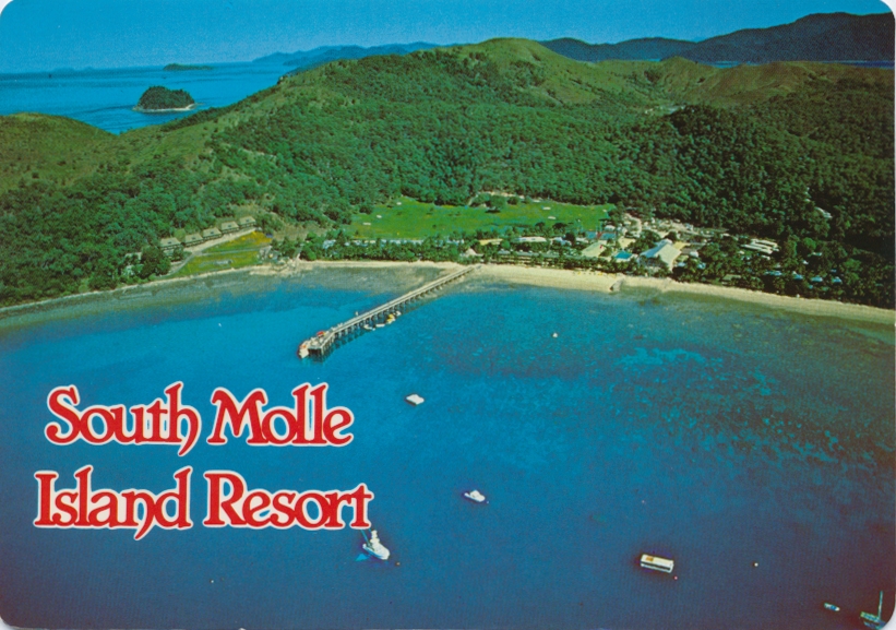
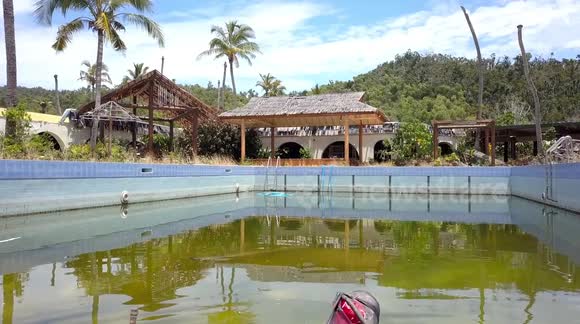
We called at Hook Island, and then South Molle Island – memorable to the kids because of its magnificent swimming pool.

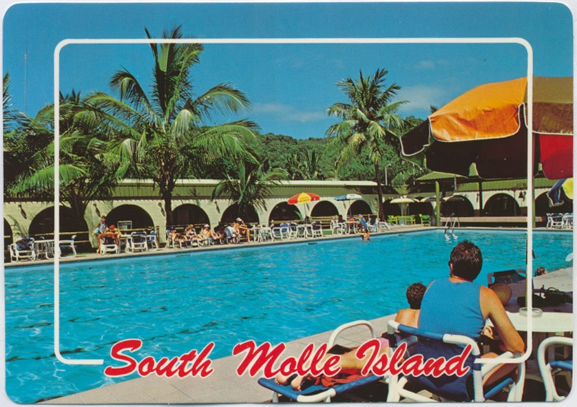
These islands are a tourism magnet – or they were before Cyclone Debbie arrived. Cyclone Debbie, in January 2017, wiped out the South Molle Resort. It now lies rotting away in the heat, its fine pool derelict.

South Molle Resort pool three years after Cyclone Debbie newsflare.com

The climate is challenging. It’s also extremely expensive to build and maintain isolated island resorts to the high standards expected by modern tourists. Many of these idyllic places may never recover, but in the Whitsundays, Hayman, Daydream, and Hamilton Islands have reopened for business.

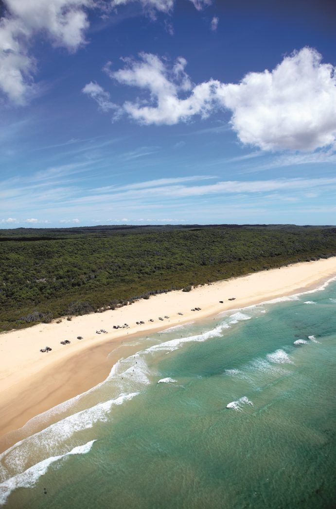
Fraser Island (K’gari), the world’s largest sand island, is 122 kilometres long, and World Heritage listed for its variety of outstanding natural features – rainforest, long sandy beaches, gorgeous freshwater lakes perched in its sand dunes.

Two of Sidney Nolan’s iconic Fraser Island paintings in Queensland Art Gallery

With friends in a 4WD we drove up that wonderful stretch of beach past people swimming and sunbathing and fishing in the surf.

Fraser Island queensland.com

Crossing the island on sand tracks we visited Lake Mackenzie and the beautiful clear water of Eli Creek, and stayed the night at Kingfisher Bay Resort.

Late last year, a bushfire started from an illegal campfire in the national park in the northern part of Fraser Island was allowed to burn through much of the precious bushland before serious firefighting began. Professional firefighting resources were not brought in until “assets” were under threat – Kingfisher Bay Resort, for instance. If the World Heritage forests of Fraser Island are not its chief “assets”, however that is defined, I don’t know what is.

Fraser Island burning couriermail.com.au

Do insurance companies contribute heavily to fire brigades? Maybe that has something to do with it. National parks don’t make insurance claims.

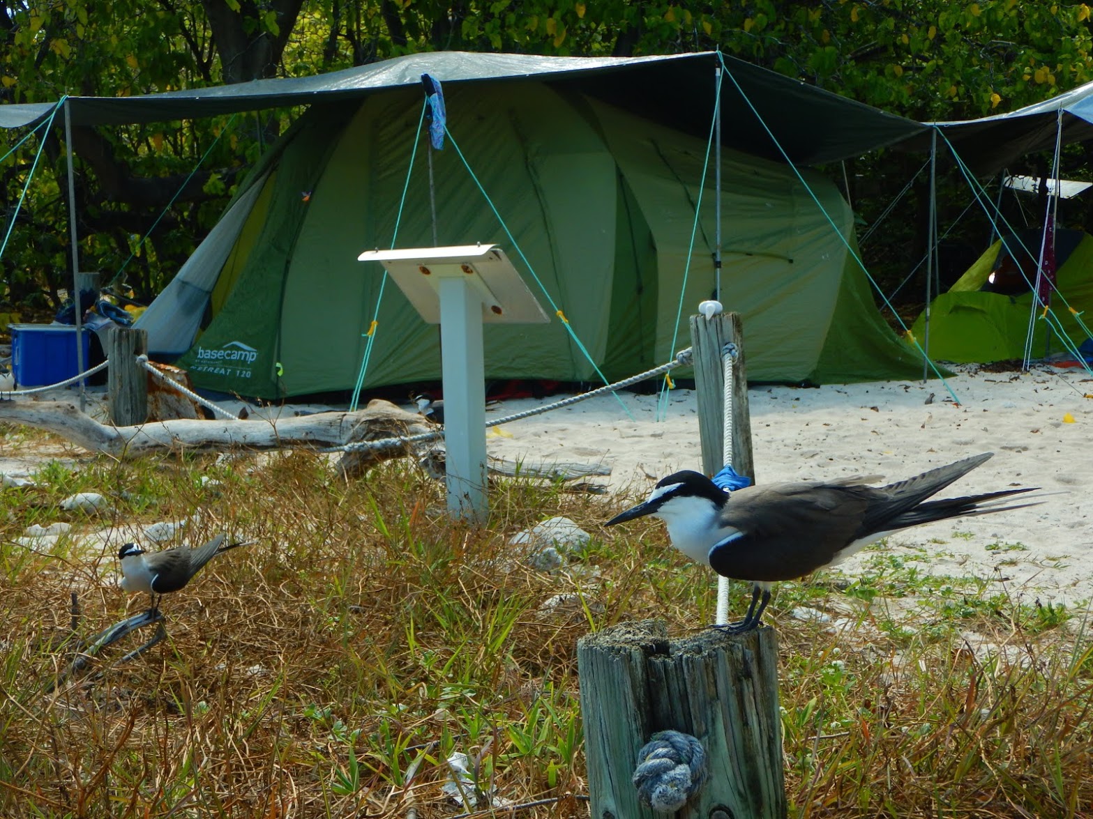
I hope one day I’ll get to visit Lady Musgrave Island (Wallanginji), a tiny, protected coral cay at the southern end of the Great Barrier Reef. I’d like to snorkel in the clear waters of the lagoon, spot green and loggerhead turtles, dolphins and birds, as our Lizzie and her family did a couple of years ago. For them, it was an unforgettable experience

Snorkelling with turtles at Wallanginji

You can camp there, with a permit, and I’ve heard that large sea turtles have been known to crawl through campsites and under tents, single-mindedly heading for a sandy spot to lay their eggs or on their way back to the sea.

Camping at Wallanginji (Lady Musgrave Island)

So many Queensland islands to write about, and I haven’t even started on the Moreton Bay islands, some of the most beautiful of them all.

No coconuts there though.

Rocky

In southeastern Rockhampton, between the river and the swamp, lies the suburb of Depot Hill. Depot Hill residents know all about floods.

In 2011, when Rocky experienced some of its worst-ever flooding, the entire city was isolated. The airport was submerged, and so was the highway. The main northern railway line, which passes by Depot Hill, was awash. Built on low, swampy land near the Fitzroy River, in spite of its name the Hill is always at risk. As the waters rose, it was decided that the suburb should be evacuated.

“I’m staying put,” said one old lady to the television cameras. “I’ve been here for sixty years, and my house has never flooded.”

Power to the area was cut, but still people stayed. Most of the houses there are high-set, and the media showed locals sitting on their front steps, drinking beer and watching the floodwaters.

rockhampton depot hill floods 2011 abc
Depot Hill during the 2011 floods ABC Capricornia: Alice Roberts

The Sydney Morning Herald reported it:

An old pine desk is drying beside Del Moss’s house in Depot Hill – drawers pulled out, in case they swell. ”It floated past yesterday. And it’s better than mine,” the 75-year-old says. ”Three lounge suites went past the other day. It was like the Sydney to Hobart watching them. If you don’t laugh, I suppose, you cry.” [Sydney Morning Herald”, 08-01-2011]

Livestock from the nearby Common took refuge on the Hill. One photo showed a house above the flood level with a goat on the landing and a donkey and a camel in the front yard.

rockhampton camel debbie
Camel in the Cyclone Debbie floods, Rockhampton, 2017

Four years later, in 2015, Rocky flooded again. This time, Cyclone Marcia was to blame. Since the previous floods, one Depot Hill grandmother had invested in a kayak for getting to the shops. Depot Hill people are proud of the way they cope, but this time it exhausted even the most stoic – not just at the Hill, but across the damaged city, with thousands of households without power, its citizens cleaning up in a heat wave.

Rockhampton Regional Libraries are a great asset to the city. Following the visit of Cyclone Marcia, the Library, via its Facebook page, invited the city in.

         With most of us still without power, a great place to spend the day will be Rockhampton Regional Library. Open again tonight until 10pm! Enjoy our air conditioning, watch a movie, grab a coffee, charge your devices, read a book, access free Wi-Fi, have a chat to the ladies from the Red Cross or visit the nurses for a health check. We have it all at the library today and would love to see you here!

Founded in 1858, Rockhampton is one of Queensland’s oldest cities, and, lying as it does on the Tropic of Capricorn, most of the time it has an ideal climate. Like Cairns, Townsville, and other coastal cities, it was first developed as a port, servicing the pastoral industry. The railway was built west from Rockhampton before the coastal line was completed, and long before the Bruce Highway came into existence.

Rocky has a notable collection of substantial old buildings, as well as typical old-style, high-stumped, timber tropical housing, such as those of Depot Hill.

IMG_20180703_085012_resized_20180714_112257698
A house at Depot Hill in dry times

Rockhampton Art Gallery has one of the finest regional collections in Australia, including a magnificent collection of mid-twentieth century Australian art. The city has renowned Botanic Gardens, as well as the splendid Kershaw Gardens.

IMG_20180703_091017_resized_20180714_112352448
The famous banyan trees of Rockhampton Botanic Gardens

As a city that services beef cattle country, Rocky is also known for its many statues of bulls, in parks and median strips – in recent years often photographed surrounded by floodwaters. There’s also a steady business in supplying replacement testicles for these bulls, as they are always losing them, sawn off in the dead of night. Rocky’s bulls’ balls are evidently prized as collectables.

In April 2017, the floods were on again, when Cyclone Debbie, one of the most widespread and expensive of all, made its slow and devastating way down the coastal ranges, from Airlie Beach all the way to Lismore.

Rockhampton swollen Fitzroy 2017
The swollen Fitzroy River after Cyclone Debbie, April 2017 ABC

This time most of the water came down the Fitzroy from the ranges to the west, and the floods were predicted to reach the highest level for sixty years. It didn’t reach that peak in Rockhampton, but once again the city was in clean-up mode for weeks. Once again, calls were made to build a levee to protect the city. Maybe that will happen one day; but in the meantime, the people of Rockhampton will stay prepared.

This is a tough old city.

Rockhampton bull Debbie RACQ Helicopter

Horror Stretch

Murder.

Travellers shot in their cars or sleeping bags.

Frightening reports in the papers.

In the 1960s and 1970s, Central Queensland place names Funnel Creek, Lotus Creek and Connors River held a weight of menace. Across that decade, several travellers were murdered by strangers when pulled up alongside the Bruce Highway between Marlborough and Sarina. The Marlborough Stretch became known as the Horror Stretch.

In his 2002 book “Seven Versions of an Australian Badland”, historian Ross Gibson writes in detail about those random murders and the other violent acts that occurred in this region over the previous century.

He writes, “This stretch of country is an immense, historical crime scene.”

Gibson also describes its cyclones and floods; and it was because of floods that Con and I once found ourselves stranded here with our children.

In the early January of 1974, on our way north to Cairns, we drove the Horror Stretch, as we had done before; but this year was different. This year was very wet indeed. Later that month, Australia Day weekend, record floods would inundate Brisbane.

From our home in Burketown, we had driven down to Brisbane for Christmas – 2200 kilometres of bitumen and gravel, with two young children and no car air-conditioning. But we were young, and we were used to it.

In those days, the Burketown water supply was untreated. We had a rainwater tank for drinking, but our bath water came from a lagoon where the local kids swam. It is not surprising that when, over Christmas, I began to feel ill, a doctor diagnosed hepatitis A.

There was nowhere for us in Brisbane, with me suffering from an infectious disease.

“I could have you taken into custody,” said the doctor. “If you don’t undertake to keep yourself away from people, that’s what I’ll do!”

We had a holiday apartment waiting for us in Cairns, and so we set out on the three-day journey north, in spite of warnings of flood rains along the way.

We crossed Lotus Creek on our second day on the road, 120 kilometres north of Marlborough and driving through rain, dipping down on to the narrow, single-lane bridge, with swirling, brown waters close beneath its decking, then up past the roadhouse on the north bank.

lotus creek roadhouse
Lotus Creek Service Station after Cyclone Debbie, March 2017. Rockhampton Morning Bulletin

Twenty kilometres further on we crossed the Connors River, with even higher water; but when we reached Funnel Creek, we were stopped. Water was racing over the bridge and halfway up the flood marker.

“We’re going back,” called out one of the other travellers pulled up at the flooded bridge. “Connors River is coming up. If it goes over the bridge there, we’ll be stranded.”

Worried, we turned back too, crossed Connors River safely and spent that night in the car, parked beside the road, just south of the river. The rain poured down, so we had to close the windows, except for a crack. It was hot, and there were mosquitoes.

We locked the car doors and tried not to think of how many people had been murdered along this road. Fourteen months later, skydiving couple Noel and Sophie Weckert would be shot by strangers here at Connors River.

noel weckert
Back row, 4th from left – skydiver Noel Weckert. South Australian Skydivers

Next morning, we drove further south, hoping to get back to Marlborough; but now the water was over the bridge at Lotus Creek. We were marooned.

There were a dozen carloads of people caught there, congregated at the Lotus Creek Roadhouse. The manager let us have an old caravan out the back for that night. It was broken-down and dusty, with grimy mattresses and no bedding, but it was more comfortable than the car. And it felt safer.

There wasn’t much food at the roadhouse, but we had our own supplies – including the only bread available for breakfast next morning. We shared it with other travellers, but the manager charged us for toasting it.

After breakfast, we drove north again and joined the queue waiting at the Connors River for the water to go down. It was a long, hot wait. People shared stories about floods, snakes and breakdowns. Some dozed in their cars. Our small children squatted in the gutter beside the car, playing with a toy truck.

The water was still over the bridge when cars began to cross. We took our turn, with a towel draped across the grill to minimize the wet coming in over the engine. As we drove up the slope on the other side, I bailed water out the window with an icecream container.

We did stupid things as young parents.

Having made it through to Cairns, a couple of weeks later we flew back to Burketown. The day Brisbane flooded, we were flying over the Gulf Country, across a sea of floodwater, the winding Carpentaria rivers marked only by the tops of trees along their banks. Our final leg home from the airstrip was in a tinnie.

IMG_7928
Gulf Country under floods

The highway doesn’t follow the Horror Stretch now – it takes a shorter, more easterly route past Saint Lawrence, and it’s a wide, well-made road and a pleasant, high-speed drive, with pasture and bush land, spectacular ranges in the background and station homesteads out of sight up dirt tracks and behind gates and grids. In a good season, tall grass stands golden along the road edges, bright against the blue mountain ranges.

fullsizeoutput_3ef3

Many still remember the murders of the Horror Stretch, though; and there have been even more frightening outback murders in the fifty-odd years since. There’s horror in the idea of a madman emerging from the dark lonely bush to murder a stranger.

That said, more travellers have died when driving voluntarily through floodwaters. Crossing flooded Connors River with young children in the car is the memory that gives me nightmares.

Blog at WordPress.com.

Up ↑